")
")
Author of the elaboration: prof. dr hab. Bronisław Matyja
The development of the Triassic was typical of the Central European (German) Basin in the Buntsandstein, Muschelkalk and Keuper facies. The facies have been correlated with the chronostratigraphic scheme (Fig. 8)
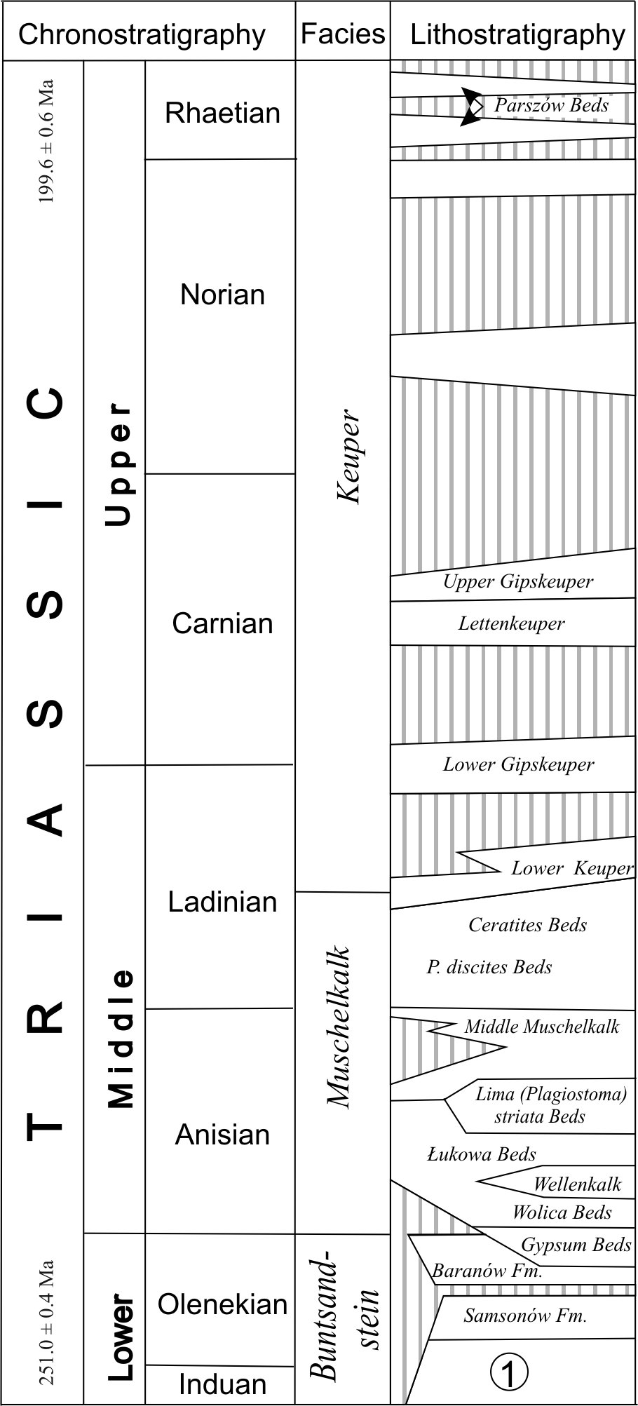
Fig. 8. Simplified lithostratigraphic scheme of the Triassic in the Mesozoic margin of the Holy Cross Mountains (after Tabela Stratygraficzna Polski [Stratigraphic Chart of Poland] 2008). 1 – complex encompassing the Siodła, Jaworzna, Opoczno, Zagnańsk, Goleniawy and Stachura formations
but due to poor biostratigraphic documentation of the Buntsandstein and Keuper, several issues, such as the position of the Permian/Triassic boundary, the ranges of stratigraphic gaps or stratigraphic correlation have been approached using magnetostratigraphy, sequence analysis or even lithostratigraphy. Therefore, the stratigraphy of the Triassic in the Holy Cross Mountains is referred to as the lower, middle and upper parts of each of the three facies.
During the Triassic Period, the Holy Cross Mountains, as part of stable Europe, moved from the dry, subtropical climate zone (c. 25°N latitude) in the early Induan, to a more humid zone located almost 1,700 km to the north (c. 40°N latitude) by the end of the Rhaetian (Nawrocki 2008). Knowledge of this migration allows us a better understanding of the characteristics and evolution of the Triassic sediments and settings.
The Palaeozoic/Mesozoic boundary in the Holy Cross Mountains is characterized by the presence of red clastic rocks, of which part are assigned to the Rotliegend and part to the Buntsandstein. The criterion used to distinguish between these two facies is the occurrence of clastic material from beyond the Holy Cross Mountains area: the Rotliegend contains only local clastic material, whereas the material in the Buntsandstein had its sources beyond the Holy Cross Mountains.
BUNTSANDSTEIN
The Buntsandstein deposits overlie Permian or older rocks. The relationship to the older basement can be observed on Miedzianka Hill, in Miedziana Góra, Doły Opacie, Jaworznia, Szczukowskie Górki, Wietrznia, Zachełmie (Chapter 3.16), in the cross-cut of the Warsaw-Cracow Road in Radkowice, and in clastic veins on Zamkowa Hill, Zelejowa Hill and Rzepka Quarry (Chapters 3.8 and 3.9). This means that a variable basement morphology occurred during Buntsandstein sedimentation, which is also reflected in the diverse and peculiar thickness distribution, varying from zero to several hundreds of metres. It has to be remembered, however, that the Holy Cross massif that dominated the morphology gradually changed from an area with prevalent erosion to much lower ground in relation to neighbouring zones. Beside clastic sedimentary rocks, the source rocks of the terrigenous material included igneous rocks (supplying tourmaline, garnets, zircon, rutile, muscovite, and biotite) and to a lesser extent metamorphic rocks (supplying staurolite, sillimanite, and epidote – Burzewski and Heflik 1962). Erratics of volcanic rocks in the Buntsandstein conglomerates have been noted in the vicinity of Jaworznia Quarry by Fuglewicz (1967). They represented rhyolite or dacite lavas and porphyry tuffs. Such igneous and metamorphic rocks are not present in the area of the Holy Cross Mountains. Source areas of these rocks were searched for by looking for potential occurrences of crystalline rocks and indicators of transport directions of clastic material. Both trails lead to the south and south-east of the Holy Cross Mountains (Senkowiczowa and Ślączka 1962).
The Buntsandstein facies comprises clastic deposits in its lower and middle parts and the carbonate deposits of the Röt facies. They correspond to the Induan and almost the entire Olenekian, although there is “general agreement” (Haas and Götz 2008) that in the German Basin, the Permian/Triassic boundary is located within the Buntsandstein facies. A similar opinion on the position of this boundary in the Holy Cross Mountains was expressed by Ptaszyński and Niedźwiedzki (2004).
The Buntsandstein deposits record five transgressive-regressive cycles. Three lower cycles are referred to the lower and middle Buntsandstein (Kuleta and Zbroja 2006), and the two latter cycles to the Röt (Senkowiczowa 1970; Szulc 2000). The cycles are variably recorded in the lithologies and thickness of the Buntsandstein facies and comprise the following three parts of the Mesozoic margin:
- north-eastern, located to the north of the Holy Cross Fault and close to the margin of the East European Craton, characterized by non-deposition and/or erosional intervals and a contribution of coarse-grained and clastic sediments in the Röt facies distinctly larger than in other parts;
- north-western, located also to the north of the Holy Cross Fault, with the thickest (900-1100 m) and most complete successions;
- south-western, with relatively small and variable thicknesses (0-400 m) and an absence of some parts of the cycles.
The transgressive-regressive cycles in the Lower and Middle Buntsandstein are presented after Kuleta and Zbroja (2006). The first cycle includes deposits (Fig. 8) that in direct vicinity of the Palaeozoic of the Holy Cross Mountains are red-brownish and brownish-green marly mudstones, locally interbedded with fine-grained sandstones and conglomerates; they are interpreted as representing a lacustrine setting (Siodła Formation). They are overlain by brownish-grey fine-grained sandstones (Jaworznia Formation), occasionally with conglomerates and breccias in the lowermost part (Zachełmie Member). The environment of the Jaworznia Formation is attributed to a backshore alluvial plain. Towards the west, probably collaterally in relation to the upper part of the Siodła Formation and the Jaworznia Formation, occur brownish sandstones, mudstones with a high content of mica and claystones (Szczukowice Formation). They were formed in a lacustrine setting or a shallow sea bay; they occur in the axial parts of the Piekoszów and Gałęzice-Bolechowice synclines and can be directly observed in Jaworznia Quarry. The regressive phase of the first cycle is represented by sandy and sandy-conglomerate deposits of the Zagnańsk Formation, which form a continuous layer up to 300 m thick that presently surrounds, and during the Triassic covered, a large part of the massif. The formation contains also grains of volcanic and metamorphic rocks (Burzewski and Heflik 1962; Fuglewicz 1967), whereas measurements of transport directions of the clastic material indicate southern and south-eastern source areas (Senkowiczowa and Ślączka 1962). The close vicinity of the source area in the southernmost part of the north-east Mesozoic margin near the town of Opatów is indicated by polymictic conglomerates (Czerwona Góra Member). Deposits of the Zagnańsk Formation were formed in a braided river setting. In the northern Mesozoic margin, among the fluvial sediments of the Zagnańsk Formation, but usually directly on top of them, developed eolian settings with a wide range of structures typical of dune and interdune deposits (Tumlin Member). The thickness of the eolian deposits reaches 150 m.
The beginning of the second transgressive-regressive cycle is linked with a marine transgression. The Goleniawy Formation, representing the transgressive part of the cycle, includes fine-grained sandstones and ooid-bioclastic limestones with acritarchs and the bivalves Avicula murchisoni. The marine sediments were distributed in the north-western and south-western Mesozoic margin (Kuleta and Zbroja 2006). In the north-eastern margin, the second cycle and the transgressive part of the third cycle are represented by river channels and floodplain environments (Wióry Formation), and in the area of the present-day Padół Strawczyński or within the Gałęzice-Bolechowice Syncline the entire second and third cycles are represented by a meandering river environment (Piekoszów Formation). The regressive part of the second cycle is recorded as stratigraphic gaps in the direct vicinity of the Palaeozoic massif.
The lateral distribution of the transgressive part of the third cycle is restricted to the north-western margin (Stachura Formation). It includes brownish-grey clastic deposits representing different grain sizes. Fine- and medium-grained sandstones dominate in the base and top of the formation. Evidence for a marine environment are ooids, fragments of calcareous algae (?Dasycladaceae) and bioclasts. The presence of algae suggests the first connections of the Holy Cross Mountains area to the Tethys Ocean (Szyperko-Teller and Moryc 1988; Szulc 1995), although the lack of marine sediments in the north-eastern and south-western margins may suggest a rather complicated pattern of these connections. The regressive part of this cycle is represented by continental deposits of the Samsonów Formation, widely distributed within the margin and represented mainly by brownish and varicoloured mudstones and claystones with limestone nodules. Deposits of this formation represent environments of meandering rivers with wide floodplains and lacustrine settings.
The thickness of the Middle Buntsandstein in the closest vicinity of the Palaeozoic of the Holy Cross Mountains reaches up to 200 m, but increases three-fold towards the north-west.
The boundary between the Middle and Upper Buntsandstein is marked by a basinwide unconformity (Szulc 2000). Transgression of the Röt sea in the late Olenekian covered the Holy Cross Mountains area and reached the hilly upland of the Lublin area in the east of Poland. This source area is indicated by transport directions, facies distribution and thickness (Senkowiczowa and Ślączka 1962). To the north of the Holy Cross Fault, a relatively thin sandstone-claystone-marly facies developed in the north-eastern margin. To the west, the number of marly intercalations significantly increases and in the north-western margin dominates a thick (up to 230 m), limestone-marly-sulphuric succession. The evolution from deltaic to marine settings and from fluvial and lacustrine to marine settings was noted twice in the north-eastern margin (Senkowiczowa 1970). These cycles are even more evident to the north-west, where the regressive part is represented by two horizons of evaporites (Gypsum Beds I and II, Fig. 8). In the south-western margin, normal marine carbonate sedimentation took place at that time, with up to 100 m thick, thin-bedded marls and limestones with the index bivalve Costatoria costata.
MUSCHELKALK
During the development of the Muschelkalk facies, the area of epicratonic Poland became a peripheral sea of the Tethys Ocean. Opinions vary whether the connection with the ocean was through two, more or less narrow, zones: the East Carpathian Gate, located between the margin of the East European Craton and the Małopolska Massif, and the Silesian-Moravian Gate, located between the Małopolska Massif and the Vindelico-Bohemian Massif (Szulc 2000), or rather was a wide connection (Ivanov 1998) that did not preserve any record of these massifs.
The Muschelkalk facies developed around and within the Holy Cross Mountains, although there is also evidence for the occurrence of a still uncovered post-Variscan relief in Middle Triassic times. A detailed stratigraphic scheme of the Muschelkalk has been presented only for the south-western margin (Fig. 8). Individual lithostratigraphic units encompass the interval between the Anisian (Nawrocki and Szulc 2000) and the lower Ladinian (Trammer 1975).
Senkowiczowa (1973) distinguished here the following stratigraphic units:
- Wolica Beds (c. 6 m thick): thin-bedded grey micritic limestones with interbeds of bioclastic limestones and yellow marly limestones, interbedded with “wellenkalk” yielding rich fauna; the “wellenkalk” is a type of limestone that does not have flat tops and bases;
- Wellenkalk (22 m thick): thin-bedded grey limestones with interbeds of wavy limestones;
- Łuków Beds (30-40 m thick): light cream coloured limestones with flints and rare interbeds of oolite limestones;
- Beds with Plagiostoma striata (formerly Lima striata) (20 m thick): grey nodular limestones, intercalated with marls and marly shales, containing abundant bivalves and brachiopods.
The feature used to distinguish rocks referred to the “Middle Muschelkalk” was the lack of fossils. The Middle Muschelkalk comprises a 49 m thick complex of limestones, dolomitic limestones, calcareous dolomites and subordinate clay shales. The intensely dolomitized part occurring in the middle part of the succession enables the sub-division of this set into the Sub-Dolomitic Beds, Dolomitic Beds and Supra-Dolomitic Beds (Senkowiczowa 1970).
The appearance of limestones rich in fossils defines the boundary with the Beds with Entolium discites (formerly Pecten discites) (9 m thick). The latter are represented by light, yellowish, sometimes grey limestones with glauconite, often with abundant shells of the bivalve Entolium discites. In the vicinity of Skarżysko Kamienna the beds contain sandy interbeds. The limestone succession is terminated by the Ceratites Beds (10 m thick), which are represented by nodular limestones containing numerous ceratite moulds, and capped by 20-30 cm thick terebratulid coquina beds, composed of the shells of Coenothyris cycloides.
This lithostratigraphic subdivision is applied to the entire area of the Mesozoic margin (e.g. Szulc 2000), although in the north-eastern margin there are numerous non-depositional gaps and the contribution of clastic rocks is higher.
According to Szulc (2000), three transgressive events are marked in the Muschelkalk; the beginning of each event was related to strong influence from the Tethys Ocean, and its end – to the occurrence of dolomites, gaps and karst phenomena. Domination of carbonate sedimentation terminated with the end of terebratulid coquina deposition; this event marks the disappearance of a normal marine sedimentary environment and the beginning of Keuper facies deposition. Worth noting is the diachronous upper boundary of the Muschelkalk between the Holy Cross Mountains and Germany (Trammer 1975): the Keuper facies had already appeared in the late Ladinian in the Holy Cross Mountains whereas at that time Muschelkalk deposition was still taking place in Germany.
KEUPER
The thickness of the Keuper facies, although locally quite variable, reaches up to 400 m in the south-western margin, increases to 600 m in the north-western margin, and is over ten to several tens of metres in the north-eastern margin. The transition between the Muschelkalk and the Keuper facies is continuous. The Keuper facies appears in the late Ladinian (Fig. 8) and is present until the end of the Triassic, which means that it dominated over most of the Triassic Period (over 32 million years). The sedimentation is interrupted by long periods of non-deposition and erosion. Distinct discontinuity surfaces, often traced over a vast area, and a “unique facies unification of particular lithological formations” have become the basis for applying depositional sequences used in the German segment of the basin to local stratigraphic subdivisions (Pieńkowski 2009). These sequences have been distinguished in Central Poland, to which, however, belongs only the north-western margin of the Holy Cross Mountains. They are much less distinct in the north-eastern and south-western margins, located in the peripheral parts of the Keuper sedimentary basin.
Prior to the Norian, in the area encompassing the present-day Holy Cross Mountains and their Mesozoic margin, developed a surface tilted to the north-west, which in the Radom-Kielce area had significant height differences (Deczkowski and Gajewska 1997). At the same time denudation of previous Keuper sediments took place, as well as Muschelkalk, Buntsandstein and older rocks, the intensity increasing towards the south-east.
During the Norian the climate was hot and semi-dry, with tendencies towards increased humidity, which caused the gradual disappearance of evaporites, the formation of fluvial and lacustrine deposits, return of vegetation, appearance of tetrapods and the first dinosaurs, although the rocks still had a reddish colour. Two depositional sequences have been distinguished here (Pieńkowski 2009) within the older Grabowa Formation and the younger Zbąszynek Beds. In the south-western margin, correlatives of the Grabowa Formation include (Gajewska 1997) the upper part of the Lower Variegated Series, composed of mudstones, subordinate sandstones, claystones and the so-called Lisów Breccia (Czapowski and Romanek 1986). Correlatives of the Zbąszynek Beds include (Gajewska 1997): the Upper Sandstone Complex, comprising cross-bedded sandstones, and the Upper Variegated Series (Czapowski and Romanek 1986). The Lisów Breccia is also present here, considered to be a result of rapid washing-out of the eroded basement rocks by torrential rains (Szyperko-Teller 1961; Maliszewska 1972), or as ‘reworked’ nodules forming a soil-type residual conglomerate (Szulc 2005 fide Szulc 2008).
The Rhaetian is marked by a distinct transition into a humid climate. Lacustrine-fluvial deposition with plant remains dominated at that time. Larger accumulations of the plants presently form coal drapes. Climate change resulted in the disappearance of variegated, and the appearance of grey, sediment colours. To the Rhaetian are assigned the “Grey Parszów Beds” (Fig. 8), included in the two last Triassic depositional sequences occurring in the north-eastern and north-western margins. Rhaetian deposits are not present in the area to the south of the Holy Cross Fault (Dadlez et al. 1998).
