")
")
Author of the elaboration: prof. dr hab. Andrzej Radwański
The Palaeogene and Neogene periods, treated before 2010 as the “Tertiary”, are important time-intervals in the geological history of the Holy Cross Mountains. It was just then that the mountains were born in the topographic form persisting to the present-day.
The Holy Cross Mountains area belonged at that time to an aulacogene trough paralleling the south-western margin of the East-European Craton, and commonly referred to as the Danish-Polish Trough (Kutek and Głazek 1972; Radwański 1975). The Palaeozoic (Variscan) folded massif subsided under a several kilometres thick, siliciclastic or carbonate cover of sequences within the trough. In particular, the strata comprised over 1 km of the Triassic, about 2 km of the Jurassic, and 3-3.5 km of the Cretaceous. Their folding, combined with a tectonic reversal, i.e. their uplift, took place during the Laramide phase at the end of the Cretaceous.
The maximum Laramide uplift developed at the location where the most deeply subsided axial zone of the trough had intersected the rising zone of the fore-bulged circum-Carpathian arch, a harbinger of the present-day range of the Central Polish Uplands. This allowed the deeply subsided Variscan massif to be isostatically uplifted almost to the surface. However, it could not have been exposed until the Mesozoic cover was removed. Its removal, coupled with the erosion of Laramide folds that form the Mesozoic margin of the Palaeozoic (Variscan) core part of the present-day Holy Cross Mountains, proceeded continuously through the whole Palaeogene (Palaeocene, Eocene, and Oligocene epochs).
In the Eocene, erosion was accelerated by tropical karst phenomena (see Głazek et al. 1972) widespread at that time all over the globe. As a result of deep erosion, the Laramide orogenic belt was transformed into a land of picturesque landscapes, fragments of which have been preserved locally until today. In other words, the germinating Holy Cross Mountains bloomed into their full glory!
The removal of material eroded during the Palaeocene was dispersed and disappeared throughout the European Lowland. Neither the Baltic Sea nor the Carpathian Mountains existed at that time, and the only available transport directions were either towards the Black Sea basin, or directly to the Tethys Ocean far to the south. As a result, the morphology of the Holy Cross Mountains at the beginning of the succeeding period, the Neogene, was very reminiscent of that existing today. It has been permanently retained in the northern part of the mountains, whilst their southern part had gradually been engulfed by the new geodynamic realm of the Alpine orogeny that built the Carpathian arch and its foredeep, the Carpathian Foredeep Basin.
In the Middle Miocene, somewhere at, or around, the Langhian/Serravallian stage boundary, a widespread marine transgression propagated from the Tethys Ocean, to embrace the whole Carpathian Foredeep Basin and to be fenced by the fore-bulging arch of the Central Polish Uplands. The southern Holy Cross Mountains, especially their eroded Laramide folds, became a much dismembered seacoast. (fig. 11)
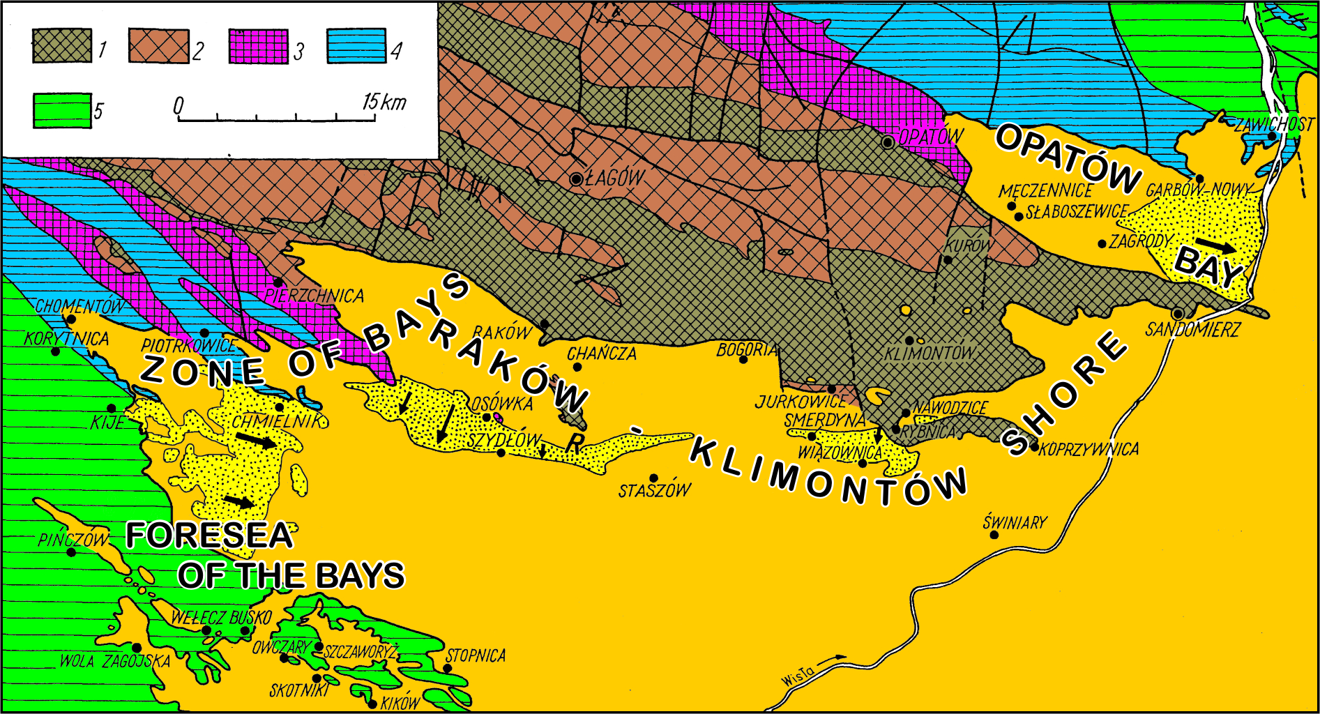
Fig. 11. Palaeographic setting of the Middle Miocene (Badenian) seacoast, to show the present-day extent of deposits preserved along the southern and eastern slopes of the Holy Cross Mountains (after Radwański 1969, 1973). Dotted is the area of the accumulation platform, distinguished as the “detrital Sarmatian” facies (Chapter 3.25); arrowed are the main routes of reworking and redeposition of the earlier Middle Miocene deposits. In the pre-Miocene basement indicated are: 1 – Cambrian, 2 – other Palaeozoic strata (Ordovician, Silurian, Devonian, lower Carboniferous), 3 – Triassic, 4 – Jurassic, 5 – Cretaceous
Erosion proceeding along the bedding strike, or fold hinge zones, when combined with the carbonate lithology of the substrate, allowed a series of bays to be formed, having been incised into the hinterland. This was a Dalmatian type of coastline, where particular bays were separated by rocky ridges, commonly built of hard and massive Upper Jurassic carbonates.
Within the bays, diverse littoral and shallow sublittoral deposits were formed. Particularly, they included fine-grained siliciclastics, marls and red-algal (lithothamnian or bryozoan limestones). In one restricted area, in the terminal part of Korytnica Bay, distinguished herein as the Korytnica Basin, very peculiar deposits, namely the yellow-coloured Korytnica Clays, replete with major amounts of shelly biota accumulated, resulting in a lithology unique among the Neogene countries in Europe.
At a greater distance from the Holy Cross Mountains shore, beyond the bays in the vicinity of the town of Pińczów, bioclastic limestones of the Viennese Leithakalk-type were formed. Commonly known as the “Pińczów Limestones”, long quarried to be used in medieval and modern architecture, they owe their fame to the fully preserved whale skeletons (Pinocetus) associated with the remains of such vertebrates as sirenians (Thalassosiren), dolphins and porpoises, crocodiles (Tomistoma), giant sharks (including the White “Man-eater” Carcharodon megalodon), diverse skates and other fish, as well as ubiquitous invertebrates of various kinds (see Radwański 1965, 1977; Czyżewska and Ryziewicz 1976; Czyżewska and Radwański 1991).
In the eastern part of the Holy Cross Mountains, along the Raków-Klimontów Shore (Fig. 11) various sands dominated, deposited in a wide array of environments: from intertidal with brown-coal at the base in the Opatów Bay, through inter- to sub-tidal in the village of Nawodzice, to progressively shallowing deeper offshores with ubiquitous fossils redeposited by storms from the eulittoral zone (Radwański 1973; Radwański and Wysocka 2004).
The regionally extensive tectonic uplift of the Holy Cross Mountains shores and the neighbouring hinterland caused a part of the earlier Miocene deposits to be reworked and redeposited towards the Carpathian Foredeep Basin. As a result, a specific facies type, the so-called “detrital Sarmatian”, was formed along the Holy Cross Mountains marginal slope in the south (Fig.11).
Erosion of the earlier deposited sandstones and carbonates and redeposition of the weathered material onto the northern periphery of the Carpathian Foredeep Basin coincided with the gradual transition of the basin into a more or less emergent lagoon, stretching into southern Poland and the western part of the Ukraine. This process was preceded by the partial evaporation of the basin and the formation of a remarkably thick (over 40 m) sequence of gypsum developed along the southern slopes of the Holy Cross Mountains. This Middle Miocene gypsum sequence of Poland and Ukraine is evidently older than, and thus has nothing in common with, the Upper Miocene (Messinian) gypsum of the Mediterranean area.
The structure of the Holy Cross gypsum, especially the main series of huge (over 3 m high), “swallow tail” crystals, involves a unique scenario in the hilly landscape near the towns of Pińczów, Busko-Zdrój and Wiślica. Subsequent karst processes resulted in the development of unforgettable views in the field, at both the macro and micro scales. The latter includes the karstified tips of the “swallow-tail” crystals, the “dente di cane” (dog’s teeth) stretching over the grasslands.
Finally, Miocene geodynamic processes encompass also volcanism. In the Holy Cross Mountains, this is documented by common ash falls. The ashes have, however, been changed by halmyrolisys processes into bentonite inliers present in some marine sequences.
With regard to the climate in the Miocene Epoch, Middle Miocene marine fauna are indicative of tropical/subtropical conditions, with a constant influx from the Indo-West Pacific bioprovince in the entire Carpathian Foredeep Basin, including the Ukraine (Radwański 1965; Bałuk and Radwański 1977; Wysocka et al. 2012; Zágoršek et al. 2012; Reinecke and Radwański 2015).
The younger epoch of the Neogene, the Pliocene, did not yield a sedimentary record in the Holy Cross Mountains. It was a time of erosion and denudation, under terrestrial conditions. Intense fluvial erosion was initiated just at the base of the Messinian Stage, already at the end of the Miocene (Gutowski 1987; Górka 2003). Such intense erosion was obviously caused by the lowering of the base of a pre-Dniester River, and the Black and Mediterranean seas in Messinian times. The Baltic Sea did not yet exist, but the Carpathian ranges had been rising, and all river outflow was directed to the Black Sea.
The lack of any sedimentary activity during the Pliocene in the Holy Cross Mountains makes climatic conclusions very imperfect, or speculative. Some floristic dates referred to as Pliocene in the Carpathians indicate a climate similar to that of our times (Lilpop 1957; Radwański 1977), thus providing evidence of a progressive climatic deterioration, just foreshadowing the Great Ice Age of the Pleistocene.
